The Cheviot Circular
| OS Map : | 75 |
| Start : | LangleeFord |
| NT950220 | |
| 255 | |
| Langleeford in Harthope Valley | |
| Summary : | Langleeford - Scald Hill - The Cheviot - Comb Fell - Hedgehope Hill - Langleeford. |
| distance : | 15.0km. |
| ascent : | 770m. |
| time : | 5hr. 50min. |
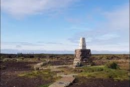
The Cheviot summit cairn, grass rather than peat underfoot now.
cheviotwalks.org
Wooler
Current Weather
Last Updated today at : 19:32:16
| Overall : | overcast clouds |
| Temperature : | 6degC. |
| Wind Speed : | 16km/hr. |
| Wind Direction : | ENE |
| Clouds : | overcast clouds |
| Precipitation : | none |
| Sunrise : | 9:36:18 |
| Sunset : | 16:39:51 |
| (Times are BST) |
Data from openweathermap.org
The Cheviot sits at the top of England nearly up at the Scottish Border. Whilst maybe not geologically part of the Pennines, it has all the features. The most popular route skirts around the Harthope Burn taking in Comb Fell and Hedgehope Hill as well as The Cheviot. Underfoot this can be boggy, well very boggy at some times but the underfoot conditions have been much improved from the days of 1m peat at the summit. Due to the height, there is a great view from The Cheviot down through Notrthumberland and over to the coast as well as the nearly hills. As well as the hills dominate the views from much of Northumberland. The route is a circular around the head of the Harthope Burn, taking in The Cheviot, Coombe Fell and Hedgehope Hill. Whilst often wet there are reasonable paths throughout.
Start at the end of the road, just short of the Langleeford farm in the Harthope Burn Valley.
From Langleeford there is a good path up to Scald Hill. It is straight up from the valley until the summit of this mound. The path continues up the north east flank of The Cheviot taking the direct route to the summit. In past days the summit was waist deep peat but now there is a path and it is safe to get to the top even in wet weather. (4.5kms. 560m. 2hrs. 30min.)
Leave the summit is a south west direction, following the good path, to get to Cairn Hill. Now descend steeply to the source of the Harthop Burn, and then steeply up to the summit of Coomb Fell. (4kms. 70m. 1hrs. 20min.)
The path to Hedgehope Hill is obvious, along the ridge between the two hills. Follow this down to the col and then back up to Hedgehope Hill. (2kms. 140m. 1hrs. 0min.)
The final section is back to Langleehope. Folow the path north easterly from the top of Hedgehop Hill. Pass Long Crags on the left and then the col between these crags and Langlee Crags. Here there is a path junstion. Take the left path for a short distance that leads to a track. Follow this track back to Langleeford. (4.5kms. 0m. 1hrs. 20min.)
w : https://www.gritstoneedge.co.uk
e :
 My Blog
 gritstoneedge instagram
 gritstoneedge linktr.ee
Disclaimer :This site has links to many adventures in the outdoors, walking or cycling in hills and moors, within the UK. These can be dangerous activities. Conditions can change rapidly in the outdoors. The information and links provided on this site is given in good faith. gritstoneedge.co.uk cannot be held responsible for any loss or injury caused by encouraging you into the outdoors of by the accuracy of the information provided on this site.
© gritstoneedge.co.uk all rights reserved 2015-2025